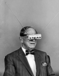
maybe....
TL 15 Xenoarchaeology Field and Excavation Tools
At Tech Level 15, a
trained xenoarchaeologist relies upon a highly integrated field system. The emphasis remains on examining, recording, and preserving a site before anything is disturbed or removed.
The technology makes excavation extraordinarily precise,
but it does not replace the archaeologist. Once a layer is removed, its original relationship to everything around it cannot be physically restored. The equipment preserves evidence only when used with sound archaeological judgment.
THE TL 15 XENOARCHAEOLOGY FIELD KIT
Multispectral Survey Visor
A survey visor combines magnification, low-light, infrared, ultraviolet, polarization, chemical-fluorescence imaging, and other specialized filters. It can reveal inscriptions, repairs, residues, weathering, and markings invisible to normal sight.
The visor can be integrated into PRIS glasses, allowing information and sensor results to be projected directly into the archaeologist’s field of view.
Portable Densitometer and Subsurface Scanner
This instrument uses terahertz imaging, ultrasound, ground-penetrating radar, and gravitic-density readings to examine walls, containers, and buried objects without opening or exposing them.
It can reveal internal mechanisms, hidden chambers, structural weaknesses, and differences in material composition.
Survey Drones
Small gravitic drones map a site, photograph every exposed surface, and produce a continuously updated three-dimensional model. Microdrones can enter tunnels, chambers, machinery, or ruins too dangerous or inaccessible for sophonts.
Context Recorder
The context recorder continuously records the position, orientation, environment, and associations of every find. It creates a timestamped holographic reconstruction of the excavation and provides the foundation for establishing an artefact’s provenance.
Xenolinguistic Analysis Unit
This device records inscriptions and spoken material, identifies repeated structures, compares them with known linguistic databases, and proposes phonetic, grammatical, mathematical, or symbolic patterns.
It assists interpretation, but it cannot reliably translate an unknown language without sufficient samples and cultural context.
Pattern-Analysis Computer
The pattern-analysis system examines architectural proportions, star maps, symbolic arrangements, manufacturing marks, and repeated motifs for relationships that might escape unaided observation.
It is especially useful for identifying codes, recognizing recurring cultural patterns, and distinguishing writing from decoration.
Material Analyser
A non-destructive spectrometer identifies alloys, ceramics, organic compounds, crystalline structures, pigments, and trace contaminants. It can often suggest a likely technological process, manufacturing method, or world of origin.
Microchronology Kit
The microchronology kit uses several dating techniques instead of relying upon a single test. It examines isotopic decay, radiation exposure, molecular degradation, accumulated surface deposits, and the environmental history of the site.
Forensic Authenticator
This instrument compares composition, tool marks, material aging, fabrication methods, repairs, and documented provenance. It is particularly useful for detecting sophisticated reproductions, substituted components, altered inscriptions, and recently manufactured "ancient" artefacts.
Environmental Probe Package
Environmental probes measure atmospheric composition, radiation, biological hazards, temperature, pressure, vibration, electromagnetic activity, and microscopic contamination.
Remote probes normally enter sealed chambers or newly discovered spaces before members of the expedition.
Precision Sample Collector
The sample collector employs sterile micromanipulators, microcutters, vacuum collection, and molecular-scale tagging. It can remove tiny samples while recording exactly where each sample originated.
Conservation Field
A portable conservation field establishes a controlled environment around a fragile object before it is disturbed. It maintains atmosphere, pressure, temperature, humidity, radiation shielding, or vacuum as required.
Smart Containment Cases
Adjustable containment cases have inert interiors, independent environmental controls, tamper records, tracking systems, and quarantine capability.
A case can preserve an artefact without assuming that Human-normal environmental conditions are safe for it.
Universal Field Fabricator
The fabricator produces braces, sample containers, replacement drone parts, excavation tools, environmental seals, and custom mounting frames.
Responsible expeditions limit its use near artefacts until possible contamination or interference has been assessed.
Reference Expert System
The expert system contains archaeological, historical, linguistic, biological, and technological databases. It records competing interpretations and confidence levels rather than presenting every speculative identification as established fact.
ARCHAEOLOGICAL SITE COMMAND AND ANALYSIS NETWORK
A professional TL 15 expedition may employ an
Archaeological Site Command and Analysis Network, commonly called
ASCAN or simply
Site Control.
Site Control functions much like a military command-and-control network. It coordinates orbital sensors, ground instruments, drones, robots, personnel, and scientific databases into a single shared view of the excavation.
The Virtual Excavation Grid
Surveyors establish permanent reference points around the site. These create a three-dimensional coordinate lattice extending above and below the surface.
Every grain of soil, artefact, architectural feature, biological trace, and instrument reading can be located within this grid. Site Control records:
- Horizontal position, depth, and orientation.
- Soil layer and geological context.
- Time and circumstances of discovery.
- The instrument or operator responsible for the discovery.
- Environmental conditions at the time.
- Relationships to nearby objects and structures.
- The identity of anyone who handled or authorized movement of the find.
Physical stakes, markers, and string may still be used as a simple visual backup, especially when working with lower-technology personnel. The actual excavation grid, however, exists within Site Control.
The Site Control Holographic Table
The expedition command post contains a large holographic or tri-vid display showing a live three-dimensional model of the site.
The display combines:
- Orbital imagery and satellite densitometer readings.
- Gravitic-density surveys.
- Ground-penetrating radar.
- Ground and aerial lidar.
- Laser measurements.
- Multispectral imagery.
- Soil chemistry and geological data.
- Radiation and magnetic readings.
- Historical maps.
- Previous excavation records.
- Earlier academic studies.
- Drone and robot sensor feeds.
- The current positions of personnel and equipment.
The supervising archaeologist can remove virtual layers, compare the site at different times, display suspected structures beneath the ground, or reconstruct the original positions of displaced objects.
Colour-coded overlays indicate confidence levels. A clearly detected buried wall might appear as a solid structure. A possible tunnel or chamber appears translucent until additional evidence confirms it.
PRIS Integration
Each archaeologist wears PRIS glasses linked to Site Control. The system projects relevant information directly over the wearer’s view of the excavation.
An archaeologist might see:
- The boundaries of the assigned excavation volume.
- Identified soil and occupation layers.
- The projected location of buried objects.
- Approved cutting and extraction lines.
- Contamination or radiation warnings.
- The previous positions of removed objects.
- Drone and robot movement paths.
- Annotations left by other specialists.
- Real-time information from instruments operating outside normal Human vision.
A researcher can look at a buried anomaly and request its complete survey history. Site Control displays every scan of that location, the estimated composition and depth, and the interpretations offered by other members of the expedition.
Different specialists can select different overlays. A conservator might see humidity, chemical activity, and structural stresses. A linguist might see enhanced inscriptions and comparisons with known writing systems. A security specialist might see unexplored spaces, energy sources, and possible hazards.
TL 15 EXCAVATION EQUIPMENT
Gravitic Soil Separator
This instrument loosens and lifts soil using tightly controlled gravitic fields. It can remove earth in extremely thin layers without placing mechanical pressure upon a buried object.
The separator does not simply throw soil aside. Material is drawn into a controlled stream, scanned, sorted according to excavation volume, and deposited into labelled containment trays. Pollen, fibres, bone fragments, microscopic tools, and chemical traces are preserved rather than discarded.
Micrograv Excavation Head
This hand-held or robot-mounted tool produces a very small gravitic gradient that separates loose soil from a solid surface.
An archaeologist can expose the edge of an artefact a few millimetres at a time while seeing its predicted outline through the PRIS display. Safety software stops the tool if its readings no longer match the approved excavation plan.
Precision Vacuum and Particle Collector
A low-pressure collector removes dust and loose particles after they have been disturbed. Every collected particle is tagged with its three-dimensional point of origin.
The collector can separate material by density, chemical composition, biological content, or particle size without destroying its archaeological association.
Molecular Adhesion Probe
For especially fragile deposits, the probe attracts selected particles through controlled electrostatic or molecular forces. It can remove one type of material while leaving another undisturbed.
For example, it might lift windblown silicate dust from an ancient painted surface without removing the pigment beneath it.
Robotic Excavation Units
Small gravitic robots conduct much of the routine excavation. Their interchangeable equipment includes:
- Micrograv lifting heads.
- Precision vacuum collectors.
- Lidar and multispectral scanners.
- Fine manipulators.
- Chemical and biological probes.
- Conservation-field projectors.
- Cutting and drilling tools.
- Sample-storage compartments.
Some units are no larger than insects and can work inside cracks or mechanical assemblies. Larger robots remove overburden, stabilize walls, and move heavy structural pieces.
All robotic activity is recorded. Site Control can reproduce exactly where each manipulator moved, how much force it applied, and what material it removed.
Excavation Drone Swarm
A swarm of small drones continuously observes the work from multiple angles. The swarm provides:
- Centimetre-to-micrometre mapping.
- Real-time photogrammetry.
- Dust and atmospheric monitoring.
- Independent verification of object locations.
- Communications relay.
- Illumination at selected wavelengths.
- Monitoring for unauthorized movement or interference.
The drones continuously compare the current site with earlier scans. If a crack expands, a wall shifts, or an object moves unexpectedly, Site Control immediately alerts the expedition.
Remote Manipulator Frame
Large or hazardous objects are enclosed by a mobile frame equipped with gravitic lifters, manipulators, scanners, and conservation-field projectors.
The frame can excavate around an object, stabilize it, and lift it without requiring a sophont to enter the immediate area. This is particularly important when dealing with alien machinery, radiation, unstable structures, or unknown biological contaminants.
Precision Excavator
The precision excavator is a larger robotic platform designed to remove soil and debris in measured layers. Its manipulators provide tactile feedback and stop automatically when they encounter material inconsistent with the surrounding matrix.
It is normally employed for opening trenches, removing overburden, exposing architecture, and clearing collapsed structures before smaller robots begin delicate work.
COMPUTER-CONTROLLED EXCAVATION
Before soil is removed, Site Control creates a proposed excavation sequence. The senior xenoarchaeologist approves each major stage.
A typical sequence proceeds as follows:
- Satellite and aerial surveys establish the wider site.
- Ground lidar, radar, and densitometers create a subsurface model.
- Site Control identifies likely structures, artefacts, voids, and hazards.
- The archaeologists divide the site into three-dimensional excavation volumes.
- Robots remove soil in measured and recorded layers.
- Every removed layer is scanned and retained according to its original context.
- Newly exposed surfaces are mapped and examined.
- The subsurface model is revised using the new information.
- Specialists authorize further excavation, sampling, or conservation.
- Artefacts are stabilized before being moved.
The computer can recommend actions,
but archaeological authority remains with the
expedition’s trained personnel.
The system might identify the most efficient way to extract an object while failing to understand that its relationship to a nearby burial, inscription, offering, or architectural feature is more important than the object itself.
EXCAVATING AN ARTEFACT
When the system detects a possible artefact, excavation within the immediate area automatically pauses. Site Control then:
- Establishes a protected volume around the find.
- Compares all available sensor readings.
- Predicts the object’s complete shape.
- Checks for attached components or nearby remains.
- Tests for radiation, stored energy, biological material, and active mechanisms.
- Records its original position and orientation.
- Summons the appropriate specialists.
- Proposes a safe exposure and recovery plan.
The robots expose only enough of the object to confirm the computer model. Once confirmed, a conservation field stabilizes the artefact and its surrounding matrix.
The team can then remove the object alone or lift an entire block of soil for controlled excavation aboard the expedition’s laboratory ship.
SHIPBOARD AND MAJOR EXPEDITION EQUIPMENT
A properly equipped archaeological vessel or permanent laboratory might also carry:
- A full molecular-imaging chamber.
- Large-scale ground-penetrating sensor arrays.
- Sealed laboratories for hazardous or unknown materials.
- Ancient-computer interface equipment using optical and electromagnetic isolation.
- Hardened containment vaults.
- Medical and xenobiological laboratories.
- Fabrication and conservation workshops.
- Extensive cultural and linguistic databases.
- Virtual-reality reconstruction facilities.
THE XENOARCHAEOLOGIST REMAINS ESSENTIAL
A TL 15 excavation resembles a combination of archaeological fieldwork, robotic surgery, orbital reconnaissance, and a military command center. The soil may be moved by gravitics and machines,
but every action is governed by context, documentation, and
professional judgment.
A competent xenoarchaeologist must still decide:
- What constitutes an artefact.
- Which physical relationships are culturally significant.
- Whether a structure is ceremonial, domestic, industrial, or something entirely unknown.
- Whether an apparent object is a tool, organism, machine, or part of the environment.
- When excavation should stop.
- What evidence must remain undisturbed for future study.
- Whether an object can be safely moved or activated.
The technology makes excavation extraordinarily precise, but it does not make it harmless. At TL 15,
careless investigators can destroy an extraordinary amount of evidence with remarkably sophisticated equipment.
Soren Ravn;
Soren finishes his lists of required equipment and with a flick of his wrist on the smart tablet his sends the list to his list of equipment to the Baron's TriVid display tablet
"If you want this done right the first time."